Map and printable trail map
The trails are marked on the map with green lines. The cycling trail network is highlighted in blue.
Printable route map
The printable map shows the trails and other facilities on the island. Distances are also marked to help you plan your trip.
Mobile guided routes
The guided Citynomadi routes by the City of Turku provide extensive information about the island's unique nature and history. The guides provide a lot of additional information and photographs, as well as links to bird sound samples. The routes follow mainly trails, but also some roads. The cultural exercise routes also provide you with a nice selection of music to match the theme of the routes.
You can use Citynomadi in a web browser or download the app to your smart device.
Note! Printed maps of the cultural exercise routes are also available. They can be picked up free of charge from the library, the swimming hall or Market Square Monitori.
The Folk Park cultural exercise route runs around the mainland side of the island. Along the way you will discover, for example:
- the villa culture of the island
- the fortresses of the Crimean War
- Ruissalo Airport
- the Ruissalo races
- the shipyard
And, of course, you'll find plenty of music to match the theme.
Note! The link will take you to the "Ruissalo cultural exercise" level of Citynomadi, where the Kansanpuisto route is marked in green.
The Marjaniemi route, located at the beginning of the island, runs through a leafy landscape. The Marjaniemi bird tower is also located near the trail. The guided tour focuses on the nature of the island.
Note! The link will take you to the "Ruissalo routes" level of Citynomadi. Choose the route that suits you best.
The route goes around the Botanical Garden of the University of Turku, occasionally even inside the garden's fences. The route passes through a beautiful grove of oak trees. Along the way you will see large oaks and pines.
Note! The link will take you to the "Ruissalo routes" level of Citynomadi. Choose the route that suits you best.
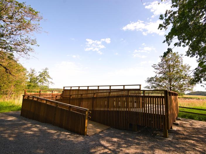
The Folk Park route runs along an easily accessible beach for part of the way. Along the way there is an accessible bird platform. The guidance will tell you about the nature and the maintenance of the island's traditional landscapes.
Note! The link will take you to the "Ruissalo routes" level of Citynomadi. Choose the route that suits you best.
Villa Circuit 3,9 or 2,4 km
The theme of the Villa Circuit is nature and the island's famous lace villas. The route follows the promenade, which is one of the best places to explore the island's historic villas. The shipping route to Turku runs close to the shore and is therefore also a popular spot for photographing ships going to Sweden. Along the route, the Crimean War-era fortresses reflect the island's history and involvement in a skirmish during the Russian rule, when British ships came to scout a possible invasion of Turku.
A shorter version of the Villa Circuit can also be taken, starting from the Folk Park and only walking around the loop at the end of the route. In this case, the distance is about 2,4 km.
Note! The link will take you to the "Ruissalo routes" level of Citynomadi. Choose the route that suits you best.
The Kuuva route runs from Ruissalon puistotie to the tip of Kuuvannokka. The start of the trail winds around the golf course. Along the way, the terrain varies between the preserved coastal area and the rocky forests. You can also visit the bird tower on the route to take in the scenery. There are also other paths in Kuuvannokka that take you around the coastal landscape.
Note! The link will take you to the "Ruissalo routes" level of Citynomadi. Choose the route that suits you best.
The Kuuva cultural exercise route circles the western part of the island. Guidance will tell you about the cultural history and nature of the island.
Along the way you will discover, for example:
- Honkapirtti
- The origins of the golf course
- Galfdahl Farmhouse, whose old cellar is now home to bats
And, of course, you'll find plenty of music to match the theme.
Note! The link will take you to the "Ruissalo cultural exercise" level of Citynomadi, where the Kansanpuisto route is marked in red.
The Kansallinen Kaupunkipuisto cycling route is a guided tour of about 20 kilometres from Kurala to Saaronniemi. The route passes through Ruissalo.
Barbecue areas and campfire sites
At Ruissalo, you can find campfire sites in the Saaronniemi area and in the Folk Park.
Saaronniemi
- Four barbecue shelters and three campfire sites in Saaronniemi
- In June, July and August, firewood can be purchased at the campsite reception. At other times, bring your own firewood.
Ruissalo Folk Park
- Two campfire sites in Folk Park
- Bring your own firewood.
Bird platform and bird tower
The accessible bird platform is located along the promenade, near the Ruissalo Shipyard.
The bird tower is located next to the golf course, along the path to Kuuva.
Beach
Ruissalo Beach is located in Saaronniemi. The beach is supervised and offers a wide range of services during the summer season. There is also a winter swimming possibility in Saaronniemi.
Outdoor gym devices
Ruissalo outdoor gym devices offer muscle training exercises in between jogging and hiking. The versatile workout area is located near the Ruissalo Shipyard.
